Welcome to our comprehensive exploration of Pakistan’s political map! This blog post aims to take you on an in-depth journey through the country’s geographic boundaries, diving into the intricate interplay between politics, geography, and history that shapes its present landscape.
From the majestic heights of the northern areas to the fertile plains of Punjab, from the vast expanses of Baluchistan to the bustling urban centers of Sindh, we’ll traverse the breadth and depth of Pakistan, unraveling the nuances and intricacies of its diverse terrain.
Get ready for an enlightening adventure through the contours of this amazing South Asian nation!
Pakistan Political Map before 2019
Before the 2019 map, Pakistan’s political boundaries were significantly different. The country’s map was drawn during the British colonial period, reflecting the aftermath of the 1947 partition that led to the creation of Pakistan and India as two separate nations.
The international boundary with India, known as the Radcliffe Line, was the most contentious, leading to territorial disputes over regions like Kashmir and Junagadh.
Internally, Pakistan’s political divisions included four provinces: Punjab, Sindh, Khyber Pakhtunkhwa, and Balochistan. These provinces were further divided into districts and tehsils. The Federally Administered Tribal Areas (FATA) were a semi-autonomous region in the northwest, along the Afghan border.
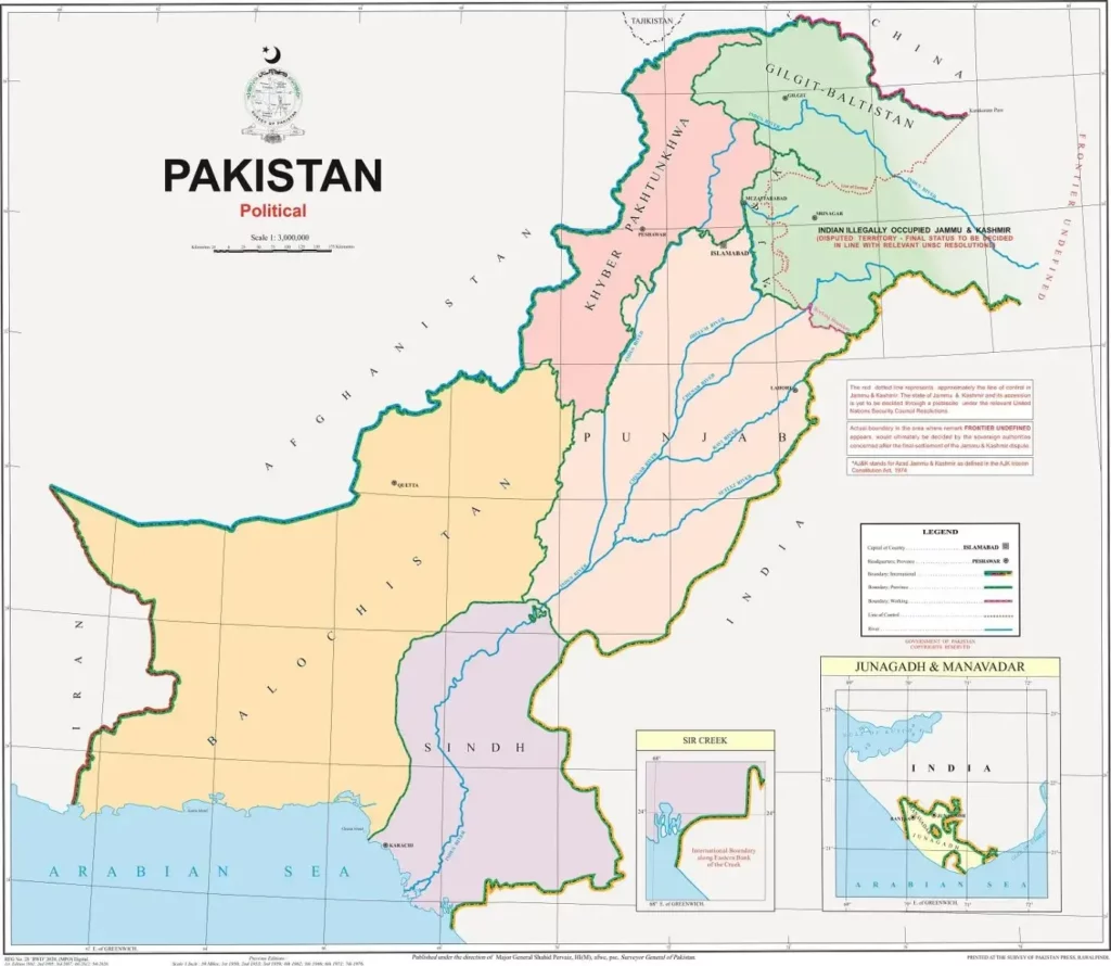
Pakistan Political Map 2019
However, in 2018, FATA was merged with Khyber Pakhtunkhwa, transforming the political map in the following year.
The 2019 map represented a significant shift, notably including the incorporation of the disputed region of Kashmir as an integral part of Pakistan.
This change sparked controversies and debates, both domestically and internationally, and continues to be a focal point in the geopolitical dialogue surrounding Pakistan.
Here is the map of Pakistan published by the Government of Pakistan.

Political Map of Pakistan PDF
Pakistan Political Map with States / Pakistan Provinces Map
The political map of Pakistan now includes five provinces: Punjab, Sindh, Khyber Pakhtunkhwa (which now incorporates the Federally Administered Tribal Areas), Balochistan, and Gilgit-Baltistan.
Each province is further divided into divisions, which are subsequently broken down into districts. These provinces and their divisions are the administrative units of Pakistan, and they play an essential role in the politics and governance of the country.
The provinces have their distinct cultures, languages, and demographics, contributing to the diverse cultural fabric of Pakistan. This diversity is a critical element of the country’s identity and is often represented delineated in its political maps.
Neighbouring Countries of Pakistan
India
India, located to the east of Pakistan, is its largest neighbor. The two countries share a long and complicated history, marked by both cultural exchange and political conflict.
Afghanistan
To the northwest, Afghanistan shares a rugged mountainous border with Pakistan. The two nations share deep historical, cultural, and economic ties, although political relations have been strained at times.
China
China, to the northeast, is one of Pakistan’s most important allies. The two countries maintain strong economic partnerships and diplomatic relations.
Iran
Iran, to the west, shares a relatively small yet significant border with Pakistan. The two countries have important cultural, economic, and security ties.
Which Country is Located in the West of Pakistan?
Iran, officially known as the Islamic Republic of Iran, is a country located to the west of Pakistan.
The two nations share a significant land border that stretches approximately 909 kilometers (565 miles), running through diverse landscapes and terrains. This border region has been the subject of various geopolitical discussions due to its strategic importance, serving as a crucial link between the Middle East and South Asia.
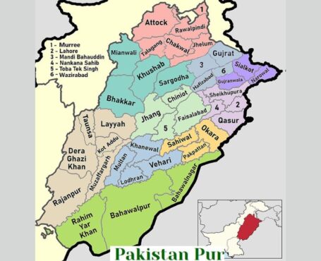
Punjab Pakistan Map

Punjab, the most populous province in Pakistan, is notably showcased on any detailed map of the country.
This region, known for its fertile lands and vibrant culture, is bordered by the provinces of Sindh, Balochistan, and Khyber Pakhtunkhwa, as well as the Islamabad Capital Territory.
Internationally, it shares borders with India and the disputed region of Jammu and Kashmir to the east.
Punjab is divided into numerous divisions and districts, each with its unique characteristics, contributing to the overall diversity of the province.
Major cities include Lahore, the provincial capital, and other significant urban areas such as Faisalabad, Multan, Rawalpindi, and Gujranwala. Punjab’s strategic location and cultural richness make it a noteworthy feature on the political map of Pakistan.
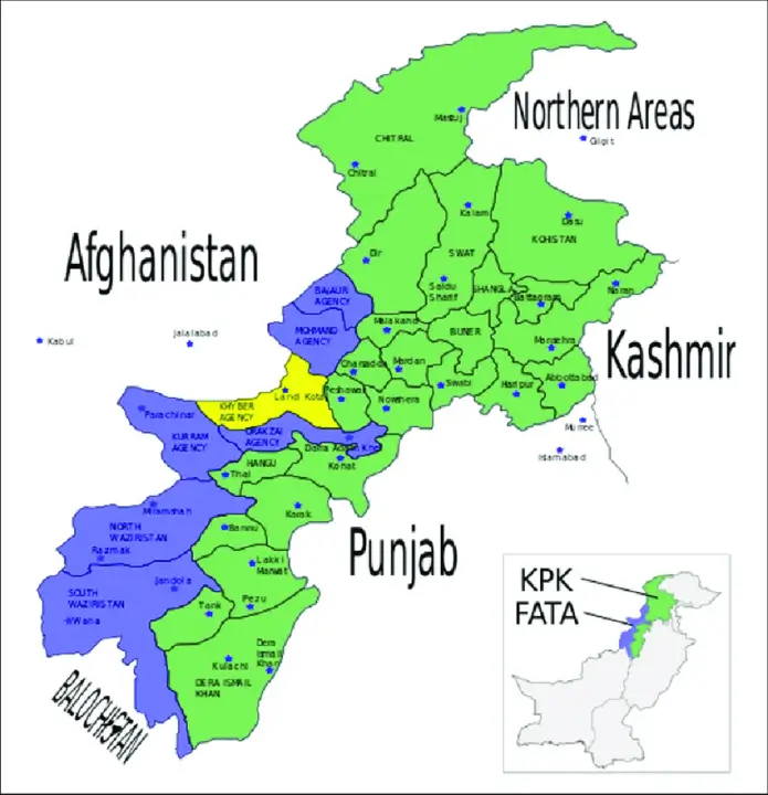
KPK Map
Khyber Pakhtunkhwa (KPK), one of the four provinces of Pakistan, is displayed prominently on the country’s map. It is located in the northwestern region of the country and is known for its diverse geographical features ranging from towering mountains to flowing rivers.
Khyber Pakhtunkhwa (KPK) shares its borders with several key areas both domestically and internationally. Within Pakistan, it is bordered by Gilgit-Baltistan to the northeast, Punjab to the southeast, and Balochistan to the south.
Internationally, it runs up against the borders of Afghanistan to the west and northwest, with the federally administered tribal areas sandwiched between the two.
Each of these neighboring regions has its unique influence, shaping the cultural, economic, and political landscape of KPK. The border it shares with Afghanistan is particularly significant due to the strategic and geopolitical implications it holds.
Recent Changes
Notably, the KPK map has undergone significant changes in recent years. The most substantial of these alterations is the integration of the Federally Administered Tribal Areas (FATA) into KPK in 2018, after a constitutional amendment. This merger has expanded the territory of KPK, adding seven tribal districts to its fold.
New Districts and Territories
These new districts include Bajaur, Mohmand, Khyber, Kurram, Orakzai, North Waziristan, and South Waziristan. Each of these tribal areas has brought a unique cultural and geographical aspect to KPK, thereby enriching the province’s diversity.
Importance of the Changes
These changes have not only altered the political landscape of KPK but have also brought about social and economic implications. The integration has led to an increase in development projects in these areas, aimed at bridging the gap between the tribal districts and the rest of the province.

Summing up Pakistan’s political map and geographic boundaries before 2019, included four provinces: Punjab, Sindh, Khyber Pakhtunkhwa, and Balochistan, and the semi-autonomous Federally Administered Tribal Areas (FATA).
The 2019 map marked a significant shift with the incorporation of the disputed region of Kashmir as part of Pakistan and the merger of FATA with Khyber Pakhtunkhwa.
We have shared some important facts about the history of elections in Pakistan.


Leave a Reply